
Introduction
The map of Europe in 1914 represents one of the most important moments in world history. It captures the political landscape immediately before the outbreak of the First World War, a conflict that would reshape borders, topple empires, and alter global power structures forever. For historians, students, educators, and history enthusiasts, understanding the map of Europe in 1914 provides crucial insight into how modern Europe emerged.
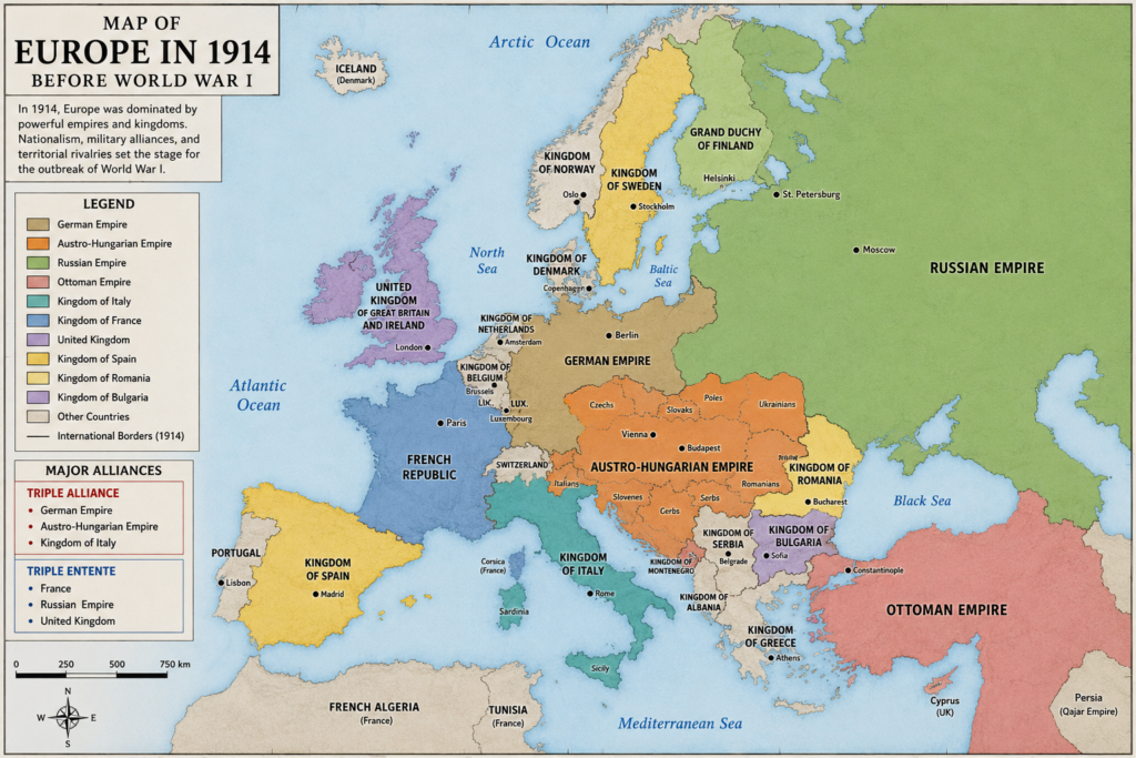
At first glance, Europe in 1914 may seem familiar, but a closer look reveals a continent dominated by vast empires rather than the independent nations we recognize today. Powerful states such as the German Empire, Austro-Hungarian Empire, Russian Empire, Ottoman Empire, and British Empire controlled enormous territories. Within just a few years, many of these political giants would disappear or dramatically transform.
Studying the map of Europe in 1914 helps explain the origins of World War I, the rise of nationalism, shifting alliances, territorial disputes, and the eventual creation of many modern European countries. Whether you’re researching history, preparing for exams, or exploring genealogy, this guide offers a comprehensive understanding of Europe’s political geography at the dawn of one of history’s most significant turning points.
Understanding the Map of Europe in 1914
The map of Europe in 1914 shows a continent divided among powerful monarchies, empires, kingdoms, and emerging nation-states. Unlike modern Europe, where most countries are independent and clearly defined, much of the continent was controlled by multinational empires governing diverse ethnic, linguistic, and cultural populations.
In 1914, political boundaries often reflected dynastic rule rather than national identity. Millions of people lived under governments that did not necessarily represent their ethnic backgrounds. For example, the Austro-Hungarian Empire contained Germans, Hungarians, Czechs, Slovaks, Croats, Serbs, Romanians, Ukrainians, Poles, Italians, and several other groups. This complex demographic structure created political tensions that contributed to instability throughout Europe.
The year 1914 is particularly significant because it marks the final moment before the outbreak of World War I. Historians frequently use maps from this period to illustrate how Europe looked before four major empires collapsed and numerous new countries emerged. The political geography of Europe after 1918 would look dramatically different from what existed in 1914.
Examining the map also reveals how strategic considerations influenced international relations. Access to waterways, industrial regions, trade routes, and military frontiers played major roles in diplomatic decisions. Understanding these geographical realities helps explain why alliances formed and why conflicts escalated so rapidly once war began.
The Major Empires Dominating Europe
One of the most striking features of the map of Europe in 1914 is the dominance of several enormous empires. These empires controlled vast territories, immense populations, and significant military resources, making them central players in European politics.
The German Empire stood as one of Europe’s most powerful industrial and military nations. Unified in 1871 under Prussian leadership, Germany rapidly developed into an economic powerhouse. Its strategic location in Central Europe placed it at the center of many diplomatic and military calculations. German industrial growth, military modernization, and expanding influence generated both admiration and concern among neighboring countries.
The Austro-Hungarian Empire stretched across much of Central and Eastern Europe. Governed by the Habsburg monarchy, it was one of the continent’s most diverse political entities. While economically important and strategically positioned, the empire struggled with rising nationalist movements among its many ethnic groups. These internal tensions would become increasingly significant as the region moved toward war.
The Russian Empire represented the largest state in Europe geographically. Extending from Eastern Europe deep into Asia, it possessed vast resources and a massive population. However, despite its size, Russia faced economic challenges, political unrest, and infrastructure limitations. The empire’s influence in the Balkans and support for Slavic populations played an important role in the diplomatic crises leading to World War I.
Meanwhile, the Ottoman Empire, although weakened compared to previous centuries, still controlled territories in southeastern Europe and the Middle East. Its gradual decline created a power vacuum that intensified competition among European powers, particularly in the Balkans.
The German Empire and Its Strategic Position
The German Empire occupied a central position on the map of Europe in 1914. This geographic reality significantly influenced both German foreign policy and the concerns of neighboring nations. Germany shared borders with several major powers, including France, Belgium, the Netherlands, Luxembourg, Denmark, Austria-Hungary, Switzerland, and Russia.
Following unification under Chancellor Otto von Bismarck, Germany experienced remarkable economic growth. By 1914, it had become one of the world’s leading industrial producers. Its manufacturing output, scientific achievements, railway network, and military capabilities positioned it among the most influential nations globally.
However, Germany’s central location also created strategic challenges. Military planners feared a two-front war involving France in the west and Russia in the east. This concern contributed to the development of military strategies designed to address simultaneous threats from multiple directions. Geography heavily influenced these calculations and shaped Germany’s alliance with Austria-Hungary.
The German Empire also controlled territories that remain historically significant today, including regions that are now part of Poland, France, Belgium, Lithuania, Russia, and Denmark. Understanding these historical borders helps explain many of the territorial disputes and political developments that followed World War I.
Austria-Hungary and the Complex Balkans
The Austro-Hungarian Empire occupied a vast region in Central Europe and represented one of the most complex political entities on the map of Europe in 1914. Unlike modern nation-states built around a single national identity, Austria-Hungary governed numerous ethnic groups with distinct languages, traditions, and political aspirations.
This diversity created both strength and vulnerability. The empire benefited from a large population and strategic location, but maintaining unity proved increasingly difficult as nationalist movements gained momentum. Many groups sought greater autonomy or complete independence, challenging imperial authority and complicating governance.
The Balkans, located south of Austria-Hungary, became one of Europe’s most volatile regions. Countries such as Serbia, Montenegro, Bulgaria, Greece, and Romania pursued their own national ambitions while competing for territory and influence. The decline of Ottoman control in the region further intensified rivalries.
Historians often describe the Balkans as the “powder keg of Europe” because numerous political, ethnic, religious, and territorial disputes converged there. The assassination of Archduke Franz Ferdinand in Sarajevo in June 1914 ultimately triggered a chain of events that led to World War I. Examining the map of Europe in 1914 makes it easier to understand why tensions in this region had such far-reaching consequences.
The Russian Empire and Eastern Europe
The Russian Empire dominated Eastern Europe on the map of Europe in 1914. Covering an enormous area, it stretched from the borders of Germany and Austria-Hungary across Siberia to the Pacific Ocean. This vast territory made Russia one of the largest political entities in world history.
Russia’s influence extended beyond its borders through cultural, religious, and political connections with Slavic populations throughout Eastern Europe and the Balkans. Russian leaders frequently presented themselves as protectors of Slavic peoples, particularly Serbia. This role significantly influenced Russian foreign policy and contributed to its involvement in regional disputes.
Despite its size and population, Russia faced numerous internal challenges. Economic development lagged behind some Western European powers, and political dissatisfaction continued to grow. Industrialization was progressing, but social inequalities and political tensions created instability within the empire.
The map of Europe in 1914 also shows several regions under Russian control that would later become independent countries. Modern nations such as Finland, Estonia, Latvia, Lithuania, and parts of Poland existed within the Russian Empire at that time. Their eventual independence after World War I dramatically reshaped the political geography of Europe.
Western Europe Before World War I
Western Europe in 1914 looked somewhat more familiar to modern observers than Eastern Europe, but important differences still existed. Major powers such as France and the United Kingdom already existed as recognizable nation-states, though both maintained extensive colonial empires around the world.
France remained determined to strengthen its position after losing Alsace-Lorraine to Germany following the Franco-Prussian War of 1870–1871. This territorial dispute remained a significant source of tension between the two countries and influenced French foreign policy throughout the prewar period.
The United Kingdom stood at the height of its imperial power. Although the British Isles themselves occupied a relatively small area on the European map, Britain’s global empire spanned multiple continents. Its naval superiority and economic influence made it one of the world’s most powerful states.
Belgium and the Netherlands occupied strategically important positions along the North Sea coast. Their locations would become highly significant once World War I began. Belgium’s neutrality, in particular, played a major role in shaping international responses to the conflict and influencing military strategies across Europe.
The Ottoman Empire and Southeastern Europe
The Ottoman Empire had once dominated large portions of southeastern Europe, but by 1914 it had lost much of its European territory. The map of Europe in 1914 shows the Ottoman state primarily confined to eastern Thrace and parts of the Balkans, while still controlling extensive lands in the Middle East. This decline was one of the most important geopolitical developments of the nineteenth and early twentieth centuries.
As Ottoman authority weakened, newly independent Balkan states expanded their influence. Greece, Serbia, Bulgaria, Montenegro, and Romania all sought territorial gains, often at the expense of Ottoman holdings. These ambitions produced a series of conflicts, including the Balkan Wars of 1912–1913, which dramatically changed regional borders even before World War I began.
The shrinking Ottoman presence created uncertainty about who would dominate southeastern Europe. Great powers such as Austria-Hungary and Russia competed for influence in the region, while local nationalist movements pursued their own agendas. This combination of imperial rivalry and nationalist ambition made the Balkans one of the most unstable areas on the European map.
Italy and the Unfinished National Question
Italy had achieved national unification in the nineteenth century, but many Italians believed the process remained incomplete. The map of Europe in 1914 shows several Italian-speaking regions still under foreign control, particularly within the Austro-Hungarian Empire. These territories included Trentino, South Tyrol, and parts of the Adriatic coast.
This issue, known as irredentism, influenced Italian politics and foreign policy. Many nationalists argued that Italy should acquire all territories inhabited by ethnic Italians. Although Italy was formally allied with Germany and Austria-Hungary through the Triple Alliance, territorial disputes with Austria-Hungary created significant tension within that relationship.
Italy’s position on the map also highlights its strategic importance in the Mediterranean. Control of key ports and sea routes gave Italy influence beyond its immediate borders. When World War I began, these geographic and political considerations contributed to Italy’s eventual decision to join the Allies rather than remain aligned with its former partners.
The Colonial Dimension of European Power
A complete understanding of the map of Europe in 1914 requires looking beyond the continent itself. European powers controlled vast colonial empires across Africa, Asia, and the Pacific. The United Kingdom, France, Germany, Belgium, Portugal, Italy, and others possessed overseas territories that provided resources, markets, and strategic advantages.
Colonial competition influenced European diplomacy and contributed to international tensions. Rivalries over territory, trade, and influence sometimes brought major powers into conflict even when disputes originated far from Europe. The global reach of these empires meant that European politics had worldwide consequences.
The map of Europe in 1914 therefore represented only one part of a much larger geopolitical system. Decisions made in European capitals affected colonies across multiple continents, while events in overseas territories could influence European relations. This interconnectedness helps explain why a war that began in Europe quickly became a global conflict.
Military Alliances and the Balance of Power
One of the most important features connected to the map of Europe in 1914 was the system of military alliances. European leaders believed alliances could deter aggression and maintain stability, but in practice they often increased the risk that local conflicts would escalate into larger wars.
Major alliance blocs in 1914
Triple Entente
France
Russia
United Kingdom
Triple Alliance
Germany
Austria-Hungary
Italy (until 1915)
The alliance system created a fragile balance of power. If one major state became involved in a conflict, treaty obligations and strategic concerns could pull additional countries into the war. The assassination in Sarajevo demonstrated how quickly this process could unfold. A regional dispute between Austria-Hungary and Serbia soon expanded into a continent-wide conflict involving multiple great powers.
The map of Europe in 1914 helps visualize these relationships because allied states often formed contiguous blocs. Geography influenced military planning, transportation networks, and strategic calculations, making the alliance system closely connected to the continent’s physical layout.
Nationalism and Ethnic Tensions
Nationalism was a powerful force shaping the map of Europe in 1914. Many people believed that nations should govern themselves and that political boundaries should reflect ethnic or linguistic identities. However, existing empires contained numerous populations with different national aspirations.
In Central and Eastern Europe, these tensions were especially intense. Czechs sought greater autonomy within Austria-Hungary. South Slavs debated various forms of political unity. Poles lived under the rule of Germany, Austria-Hungary, and Russia. Ukrainians, Romanians, and other groups also pursued national goals.
These nationalist movements challenged imperial structures and created pressure for political change. While some leaders attempted reforms, many governments struggled to accommodate competing demands. The resulting instability contributed to the broader crisis that engulfed Europe in 1914.
Economic and Industrial Geography
The map of Europe in 1914 also reflected major economic differences across the continent. Industrialization had transformed parts of Western and Central Europe, creating powerful manufacturing regions, dense railway networks, and rapidly growing cities. Germany, the United Kingdom, France, Belgium, and parts of northern Italy were among the most industrialized areas.
In contrast, large portions of Eastern and Southeastern Europe remained more agricultural. These economic disparities influenced military capabilities, political influence, and social development. Industrial powers generally possessed stronger transportation systems, larger factories, and greater access to modern weapons production.
Economic geography also affected strategic planning. Coal fields, iron deposits, major ports, and railway junctions were considered vital national assets. Control of these resources could determine a country’s ability to sustain military operations during a prolonged conflict. As a result, economic considerations became deeply intertwined with political and military decision-making.
How World War I Transformed the Map
The significance of the map of Europe in 1914 becomes even clearer when compared with the map that emerged after World War I. The war led to the collapse of four major empires: the German, Austro-Hungarian, Russian, and Ottoman Empires. Their territories were divided, reorganized, or transformed into new states.
Countries such as Poland, Czechoslovakia, Finland, Estonia, Latvia, Lithuania, and Yugoslavia appeared or reappeared as independent political entities. Borders shifted across Central and Eastern Europe, often in ways that attempted to balance national self-determination with strategic and economic considerations.
These changes were not always stable or universally accepted. New minorities found themselves living within new states, and some territorial disputes remained unresolved. Nevertheless, the transformation was profound. The Europe that emerged after 1918 differed dramatically from the imperial landscape shown on the map of Europe in 1914.
Comparing the Map of Europe in 1914 With Modern Europe
One of the most effective ways to understand the map of Europe in 1914 is to compare it with the political map of Europe today. The differences are remarkable. In 1914, large multinational empires controlled vast regions, while modern Europe consists primarily of independent nation-states with internationally recognized borders.
The Austro-Hungarian Empire alone occupied territory that now belongs to multiple countries, including Austria, Hungary, the Czech Republic, Slovakia, Croatia, Slovenia, Bosnia and Herzegovina, and portions of several neighboring states. Similarly, the Russian Empire included areas that today form Finland, Estonia, Latvia, Lithuania, Belarus, Ukraine, and parts of Poland.
The Ottoman Empire’s European territories have also changed significantly. Modern Turkey occupies only a small portion of southeastern Europe, while independent Balkan nations now control most of the region. These transformations illustrate how dramatically wars, revolutions, treaties, and nationalist movements reshaped the continent during the twentieth century.
For students and researchers, comparing historical and modern maps provides valuable context for understanding current political boundaries, cultural identities, and regional relationships. Many contemporary issues can be traced back to developments that began before or during World War I.
Why Historians Still Study the Map of Europe in 1914
Historians continue to examine the map of Europe in 1914 because it serves as a snapshot of a world on the brink of enormous change. The map reveals the geopolitical realities that influenced diplomacy, military planning, economic competition, and nationalist movements immediately before the First World War.
The map helps explain why alliances formed the way they did, why certain territories became flashpoints for conflict, and why the war spread so rapidly once it began. By understanding the geography of Europe before the conflict, researchers gain deeper insight into the decisions made by political leaders and military commanders.
Additionally, the map provides a foundation for studying the twentieth century as a whole. Many of the major events that followed—including World War II, the Cold War, the formation of new states, and European integration—can be better understood by first examining Europe’s political structure in 1914.
The enduring importance of this historical map lies in its ability to connect geography, politics, culture, and international relations into a single visual representation. Few historical documents illustrate such a pivotal moment so clearly.
Conclusion
The map of Europe in 1914 represents far more than a collection of borders and territories. It captures the final years of an old European order dominated by empires, monarchies, and competing national ambitions. Within months of the map’s creation, the assassination in Sarajevo and the outbreak of World War I would begin a process that transformed the continent forever.
Understanding the map of Europe in 1914 helps explain the origins of global conflict, the collapse of powerful empires, the rise of new nations, and the development of the modern European landscape. From the German Empire and Austria-Hungary to Russia, the Ottoman Empire, and the Balkans, every region played a role in shaping history.
For students, educators, genealogists, and history enthusiasts, studying this map provides essential context for understanding the modern world. The borders may have changed, but the lessons contained within the map of Europe in 1914 remain as relevant as ever.
As one of history’s most important geopolitical snapshots, the map of Europe in 1914 reminds us how quickly the world can change and how deeply geography influences the course of human events.
FAQs
What did the map of Europe in 1914 look like?
The map of Europe in 1914 looked very different from today’s map. Large empires dominated the continent, including the German Empire, Austro-Hungarian Empire, Russian Empire, Ottoman Empire, and British Empire. Many modern countries either did not exist as independent states or were part of larger political entities. National borders often reflected imperial control rather than ethnic or linguistic identities. This map is significant because it shows Europe immediately before World War I, a conflict that dramatically transformed the continent’s political geography.
Why is the map of Europe in 1914 important?
The map of Europe in 1914 is important because it illustrates the political situation that existed just before World War I. It helps explain the causes of international tensions, alliance systems, territorial disputes, and nationalist movements. Historians use this map to understand how major powers interacted and why the war spread so quickly after the assassination of Archduke Franz Ferdinand. It also serves as a valuable reference point for studying the creation of modern European countries and borders.
Which empires dominated Europe in 1914?
Several powerful empires dominated Europe in 1914. These included the German Empire, Austro-Hungarian Empire, Russian Empire, Ottoman Empire, and the British Empire. Each controlled significant territories and populations. These empires shaped European politics, economics, and military affairs. Their rivalries, alliances, and internal challenges played major roles in the events leading to World War I. By the end of the war, many of these empires had collapsed or undergone dramatic transformations.
How did World War I change the map of Europe?
World War I fundamentally changed the map of Europe. The German, Austro-Hungarian, Russian, and Ottoman Empires collapsed, leading to the creation of several new countries. Poland regained independence, while nations such as Finland, Estonia, Latvia, Lithuania, Czechoslovakia, and Yugoslavia emerged. Borders shifted across Central and Eastern Europe, creating a new political landscape. These changes influenced international relations for decades and helped shape the Europe that exists today.
What countries did not exist on the map of Europe in 1914?
Many modern European countries did not exist as independent states in 1914. Finland, Estonia, Latvia, Lithuania, Czechoslovakia, Yugoslavia, and others were either part of larger empires or had different political statuses. Poland was divided among neighboring powers and did not exist as an independent country. The map of Europe in 1914 therefore reflects a political structure very different from the modern nation-state system familiar today.
What role did the Balkans play in the map of Europe in 1914?
The Balkans were one of the most unstable and strategically important regions on the map of Europe in 1914. Nationalist movements, ethnic rivalries, territorial disputes, and great-power competition all converged there. The decline of Ottoman influence created opportunities and tensions among emerging Balkan states. The assassination of Archduke Franz Ferdinand in Sarajevo, Bosnia, ultimately triggered the diplomatic crisis that led to World War I, making the Balkans central to understanding this period.
Read More About: dailynwes.blog